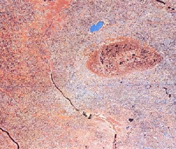
LANDSAT IMAGE OF THE TURTLE MOUNTAINS REGION, NORTH DAKOTA & SASKATCHEWAN
The ovate feature in the right-central portion of this image is the Turtle Mountains: a mesa of upper Cretaceous and Paleocene bedrock thickly-draped by glacial sediments. The prominent river in the lower-left quarter of the image is the Souris River, which flows southward from Saskatchewan into North Dakota and then sweeps back northward around the western edge of the Turtle Mountains into Manitoba. The large, bluish water body northwest of the Turtle Mountains is Manitoba's Whitewater Lake.
The U.S.-Canadian border can be discerned below the northern third of the Turtle Mountains through a slight change in reflectance, representing differences in land use; the Canadian side reflects as a deeper red. The prominent blue line south of the Turtle Mountains represents a "dropout" or failure by the satellite to record one of its scan lines.

No comments:
Post a Comment